Tocht 4x4 Le Petit-Celland - rando 24 nov 2019 - Photo
 alex12r
alex12r

Gebruiker

© OpenStreetMap contributors
Lengte
Lengte
55 km
Max. hoogte
Max. hoogte
239 m
Positief hoogteverschil
1104 m
Km-Effort
Km-Effort  
69 km
Min. hoogte
Min. hoogte
26 m
Negatief hoogteverschil
1082 m
Boucle
Boucle
Neen
Datum van aanmaak :
2019-11-24 09:18:10.821
Laatste wijziging :
2019-11-24 22:15:53.365

(0 Bericht)

4x4
4x4
3h30
Moeilijkheid : Heel gemakkelijk

Scan deze QR-code om de tocht te openen in de SityTrail-applicatie

Gratisgps-wandelapplicatie

Logo SityTrail SityTrail

IGN / Geografische instituten

SityTrail uit de App Store downloaden SityTrail uit Google Play downloaden

Logo SityTrail SityTrail World

De wereld gaat voor u open

SityTrail uit de App Store downloaden SityTrail uit Google Play downloaden SityTrail op Huawei AppGallery downloaden

Over ons

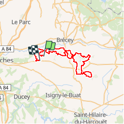
Tocht 4x4 van 55 km beschikbaar op Normandië, Manche, Le Petit-Celland. Deze tocht wordt voorgesteld door alex12r.

Hoogteprofiel

Plaatsbepaling

Land:
France
Regio :
Normandië
Departement/Provincie :
Manche
Gemeente :
Le Petit-Celland
Locatie:
Unknown
Vertrek:(UTM)
630511 ; 5394858 (30U) N.

Wandeltochten in de omgeving

Tocht Mountainbike Le Petit-Celland - Espace VTT FFC de la Vallée de la Sée - circuit n°17 - Tour de la Vallée de la Sée - Photo
Mountainbike
tracegps

Mountainbike

Zeer moeilijk
(1)
Le Petit-Celland, Normandië, Manche, France
160 km | 202 km-effort
16h 0min
Ja
Tocht Mountainbike Brécey - Espace VTT FFC de la Vallée de la Sée - circuit n°4 - Balade de la Sémondière - Photo
Mountainbike
tracegps

Mountainbike

Gemakkelijk
Brécey, Normandië, Manche, France
6,4 km | 7,6 km-effort
1h 0min
Ja
Tocht Mountainbike Brécey - Espace VTT FFC de la Vallée de la Sée - circuit n°3 - Entre Prés et Vergers - Photo
Mountainbike
tracegps

Mountainbike

Medium
Brécey, Normandië, Manche, France
14,8 km | 17,8 km-effort
2h 0min
Ja
Tocht Mountainbike Brécey - Espace VTT FFC de la Vallée de la Sée - circuit n°2 - Panoramas sur le Val de Sée - Photo
Mountainbike
tracegps

Mountainbike

Moeilijk
Brécey, Normandië, Manche, France
14,3 km | 17,9 km-effort
2h 0min
Ja
Tocht Mountainbike Brécey - Espace VTT FFC de la Vallée de la Sée - circuit n°1 - Des Romains aux Chouans - Photo
Mountainbike
tracegps

Mountainbike

Zeer moeilijk
Brécey, Normandië, Manche, France
61 km | 77 km-effort
5h 0min
Ja
Tocht Lopen Le Mesnil-Ozenne - Le Mesnil Ozenne - Photo
Lopen
tracegps

Lopen

Moeilijk
Le Mesnil-Ozenne, Normandië, Manche, France
4 km | 5,3 km-effort
19min
Ja
Tocht Mountainbike Le Mesnil-Ozenne - Le Mesnil Ozenne - Photo
Mountainbike
tracegps

Mountainbike

Gemakkelijk
Le Mesnil-Ozenne, Normandië, Manche, France
4 km | 5,3 km-effort
15min
Ja
Tocht Stappen Le Mesnil-Ozenne - Le Mesnil Ozenne - Photo
Stappen
tracegps

Stappen

Medium
Le Mesnil-Ozenne, Normandië, Manche, France
4 km | 5,3 km-effort
45min
Ja
Tocht Paardrijden Brécey - Rando brecey 2 édition  - Photo
Paardrijden
phillipine

Paardrijden

Medium
Brécey, Normandië, Manche, France
23 km | 28 km-effort
48min
Ja


Sluiten
Mijn abonnementen